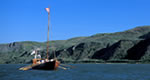
This national monument includes an ecosystem that parallels the Upper Missouri National Wild and Scenic River throughnorth-central Montana. Much of the land in this area (377,346 acres) is public land managed by the BLM. In some areas, these BLM acres are intermingled with State of Montana lands and private property. The landscape throughout this monument contains a spectacular array of biological, scientific, historic, wildlife, geological, and cultural resources mixed with a remote location that offers opportunities for solitude not commonly found today.
Map + Directions
Basic Directions
The Breaks begins at historic Fort Benton onU.S. Highway 87 and ends 149 miles later where the Robinson Bridge on U.S. Highway 191crosses the Missouri River.
We offer a compact version of Go-Southdakota for mobile users, allowing you to access just the information you need on the road. Of course, you can still use the full version of Go-Southdakota on your mobile device just as you can on your desktop.