Ancient fossils still lie hidden in the bold and bronzen buttes of Badlands National Park, a protected wilderness penetrated by hiking and biking trails.
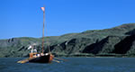
Fish Lake is set in the High Cascades between McLoughlin and Brown Mtn., both relatively young volcanoes. The lake is used as an irrigation reservoir and lake levels can be lower at the end of the summer. Boating, canoeing, camping, hiking and fishing are some of the favorite activities in and around Fish Lake. Size: 483 acres, Depth at full pool averages 18 feet and the deepest part of the lake is 31 feet. The elevation of Fish Lake is 4,642 feet.
Fishing
Fish:
Brook Trout Rainbow Trout
Fishing Methods:
Fly,Spin,Bait
Details
Size:
483 acres / .8 sq. miles
Max. Depth:
31 feet
Elevation:
4642
Season:
Year round
Water Access:
By car or boat
Camping Info
Several campgrounds are located around and nearby the lake, including Fish Lake, North Fork and Doe Point.
Additional Details:
A valid Oregon state fishing license is needed to fish within the National Forest. Licenses are sold at sporting good and other retail stores. For information on fishing times & limits a current state fishing regulation guide is generally available free at these same locations. For more information contact the Oregon Department of Fish & Game.
Amenities
Map + Directions
Basic Directions
Fish Lake is located approximately 32 miles east of Medford, Oregon.
We offer a compact version of Go-Southdakota for mobile users, allowing you to access just the information you need on the road. Of course, you can still use the full version of Go-Southdakota on your mobile device just as you can on your desktop.