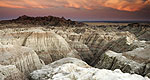
Ancient fossils still lie hidden in the bold and bronzen buttes of Badlands National Park, a protected wilderness penetrated by hiking and biking trails.
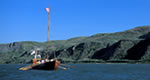
Belle Fourche Dam and reservoir are features of the Belle Fourche Project. The reservoir is located on Owl Creek, about 8 miles east of Belle Fourche, South Dakota. The name means Beautiful Forks in French and refers to the confluence of the Redwater and Belle Fourche Rivers. The primary historic site is Belle Fourche Dam, which is listed in the National Register of Historic Places. An interpretive area on the dam's south side contains exhibits and displays about the dam's construction, and a former Civilian Conservation Corps camp located near the dam that later served as a World War II Prisoner of War camp. The reservoir water surface area is 8,000 acres; available fish species include walleye, catfish, and white bass. Activities also include public use and picnic area, swimming, and boating. Open year-round.
Amenities
Map + Directions
Basic Directions
Eight miles east of Belle Fourche, SD on US 212. The city of Belle Fourche is about 57 miles north of Rapid City, SD using I-90W to SR-34, to US-85 to US-212
We offer a compact version of Go-Southdakota for mobile users, allowing you to access just the information you need on the road. Of course, you can still use the full version of Go-Southdakota on your mobile device just as you can on your desktop.