South Dakota Map

U.S. 12 Snake River Bridge to Walla Walla Scenic Byway

Basics
Length:
35 miles (56 km)

Description

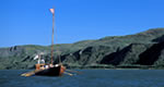
This byway traverses the Lewis & Clark Trail through rolling hills, fields and trees along the Walla Walla River from the Columbia River to the city of Walla Walla.

Details

Length:
35 miles (56 km)
Main Roads:
US-12 E

Map + Directions

Customizable Directions


Copyright © 1997 - 2024 The Go Travel Sites. All Rights Reserved and.

Email Page Link

Complete the form below to email this page to a friend or family member's email. You can send yourself an email as well. Your email and your recipient's email will NOT be shared with anyone. See our full Privacy Policy for details.
:
:
:


:
Copy Yourself on the Email Yes No
:
:

1

Select a Free Visitor Guide below

2

Complete the form to receive your guides by mail