


Contact Info
U.S. Forest Service
Black Hills National Forest
803 Soo San Drive
Rapid City, SD 57702
Black Hills National Forest
803 Soo San Drive
Rapid City, SD 57702
- Phone:
- 605-343-1567
Basic Directions
Site is 15 miles west of Rapid City off U.S. 385.
Description
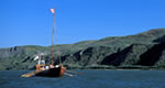
The Rapid Valley Unit of the Pick-Sloan Missouri Basin Program consists of Pactola Dam and Reservoir located on Rapid Creek about 15 miles west of Rapid City, South Dakota. The Dam is a zoned earthfill structure, 230 feet high, 40 feet wide at the crest, and 1,255 feet long. Numerous facilities associated with outdoor recreation are provided at Pactola Reservoir, including picnic grounds, campgrounds, boat ramps, a visitor center and scenic overlooks. Available fish species include rainbow trout, brown trout, and perch. Open year-round.

