Ancient fossils still lie hidden in the bold and bronzen buttes of Badlands National Park, a protected wilderness penetrated by hiking and biking trails.
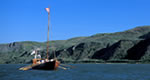
The Columbia River Gorge National Scenic Area is a spectacular river canyon cutting the only sea-level route through the Cascade Mountain Range. It's 80 miles long and up to 4,000 feet with the north canyon walls in Washington State and the south canyon walls in Oregon State. The Columbia River Gorge is more than a gorgeous, natural wonder. It is also a critical transportation corridor and is home to 70,000 people.
Map + Directions
Basic Directions
It's easy to navigate through the Columbia River Gorge.State Route 14 on the Washington side and Interstate 84 on the Oregon side are the main highways along the Columbia River. Four bridges help you get from one side of the river to the other: Cascade Locks/Stevenson; Hood River/Bingen; The Dalles/Dallesport, and Biggs/Maryhill.
We offer a compact version of Go-Southdakota for mobile users, allowing you to access just the information you need on the road. Of course, you can still use the full version of Go-Southdakota on your mobile device just as you can on your desktop.