Ancient fossils still lie hidden in the bold and bronzen buttes of Badlands National Park, a protected wilderness penetrated by hiking and biking trails.
Ten miles in length from Coal Creek Trailhead on East Fork Road (FDR 667) at Sand Creek to the trailhead on Fawn Gulch Road (FDR 666), this trail crosses the shoulder of a mountain and both ascent and descent are very steep. It can be extremely slick when wet. Highest point is 10,800 feet, total ascent is 2,800 feet.
Details
Location:
East of Pagosa Springs
Setting:
Mountainous
Length:
20 mile roundtrip
Time:
10 to 11 hours
Trailhead Elevation:
7900
Elevation Change:
2800
Season:
Summer - Fall
Map + Directions
Basic Directions
1)Go northeast on U.S. Hwy. 160 for approximately 9.5 miles. Turn right on East Fork Road (FDR 667) and travel approximately 4 miles. The trailhead is on the right before the bridge over Sand Creek.
2) Fawn Gulch Road - Go 3.5 miles northeast on U.S. Hwy. 160, then turn right on Fawn Gulch Road (FDR 666). Trailhead is on the left near the end of the road. Trailhead elevation 8,000 feet.
Below are the Free Visitor Guides for Sheridan. More Visitor Guides are available in South Dakota. Click here to view them all!
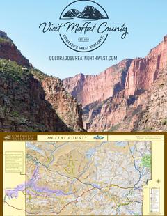
Visit Moffat County Northwestern Colorado
Visit Moffat County
Northwestern ColoradoWelcome to Colorado’s Great Northwest, Moffat County has nearly 2 million acres of public lands to explore. Experience places like Dinosaur National Monument, the Sand Wash Basin Wild Horse Management Area and free flowing rivers including the mighty Yampa, last of the wild ones! Request this Free Visitor GuideRequested!You're all set! Complete the form below to receive your guides by mail.
Switch to Mobile Browser Mode
We offer a compact version of Go-Southdakota for mobile users, allowing you to access just the information you need on the road. Of course, you can still use the full version of Go-Southdakota on your mobile device just as you can on your desktop.


")