


Basics
- Location:
- Located 35 miles east of Vancouver, WA
- Type:
- State Parks
Description
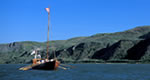
Beacon Rock State Park is a 4,650-acre year-round camping park with historic significance dating back hundreds of years. The park includes 9,500 feet of freshwater shoreline on the Columbia River. The Washington Discover Pass is required every day except for designated "Free Days".
Hours + Fees
Hours:
Summer: 8 a.m. to 10 p.m.Winter: 8 a.m. to 5 p.m. for day-use only.
Season:
Amenities
Amenities:
Picnic Area(s)
Map + Directions
Basic Directions
Located 35 miles east of Vancouver, Wash.From Seattle:Take I-5 south to Vancouver. Just north of Vancouver, take I-205 south. Follow I-205 south to the Hwy. 14 exit (last exit before crossing the Columbia River into Oregon). Follow Hwy. 14 east. Beacon Rock and the park entrance are located at mile post 35.
From Portland:Take I-84 eastbound along the Columbia River to Cascade Locks. At Cascade Locks, cross the Columbia River into Washington on the Bridge of the Gods toll bridge. Turn left onto Hwy. 14. Follow Hwy. 14 west for seven miles to Beacon Rock.NOTE: Road construction will begin in August 2006. This project consists of building a new intersection off State Route 14 and a multi-span bridge across the Burlington Northern Santa Fe railroad, approach road and other related work. The entrance to the park will not be affected and only minor delays are expected.

