


Basics
- Location:
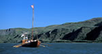
- Roosevelt Lake
- Length:
- 19.5 miles (21.4 km)
- Difficulty:
- Difficult
- Trailhead Elevation:
- 2250 feet
- Season:
- Year round
Details
Location:
Roosevelt Lake
Length:
19.5 miles (21.4 km)
Difficulty:
Difficult
Trailhead Elevation:
2250 feet
Northern Trailhead at 5600
Northern Trailhead at 5600
Season:
Year round
Fees:
No Fee
Useful Map(s):
Theodore Roosevelt Dam, Four Peaks
Map + Directions
Basic Directions
Southern Trailhead:
Vineyard Trailhead - Hwy 88
33.67650° N, 111.16104° W
Northern Trailhead:
Pigeon Spring/Lone Pine Saddle Trailhead - FR 648
33.71095° N, 111.33618° W
Vineyard Trailhead - Hwy 88
33.67650° N, 111.16104° W
Northern Trailhead:
Pigeon Spring/Lone Pine Saddle Trailhead - FR 648
33.71095° N, 111.33618° W